Forming the Landscape
Tasmania is a unique place and it all started below your feet millions of years ago. If you, like me, found geology at school boring and pointless, then I urge you to keep reading. It is the landscape that makes everything else possible, it is the geology that draws you to Tasmania. The landscape defines the weather, soil types and gives rise to the unique flora and fauna of the region.
By having a crash course in geology, we will see the landscape differently as we walk. We will see the shapes of the mountains, know how they were carved by glaciers and better appreciate how they were extruded from the earth as a fiery goo.
The Birth of a Mountain Range
The spectacular mountains we see today are a result of millions of years of rock formation, uplift, and erosion.
At the risk of sounding too much like a school teacher, let’s remember there are three major types of rocks that make up Earth’s crust.
1) Igneous rocks are formed when molten rocks cool and become hard. Igneous rocks can be plutonic or volcanic. Plutonic rocks, such as granite, form when magma cools slowly in the depths of the earth (they have big visible crystals). Volcanic rocks, such as basalt, rhyolite, and andesite, form when lava cools rapidly on the surface (the faster cooling means they are made up of smaller crystals).
2) Sedimentary rocks are built up from (well, um …) sediments. These are small bits of mineral and organic material which have been deposited by water or wind. Sediments are usually carried by rivers and left behind in basins (lakes and seas). These sediments are buried and compressed into rock strata (layers). Typical sedimentary rocks include sandstone, limestone, shale, and chert. Generally fossils are only found in sedimentary rocks (except a few pedantic examples).
3) Metamorphic rocks are pre-existing rocks that have been changed due to intense heat and/or pressure deep within the earth without completely melting. The original rocks could have once been sedimentary, igneous or even another metamorphic rock. It is a bizarre concept that rocks can metamorphose multiple times – we are talking long time scales when we talk rocks.
When rocks are squeezed and baked beneath Earth’s surface or by contact with lava at the surface, the minerals may recrystallise and change form.
How do the mountains get up high?
The theory of plate tectonics provides a big part of the answer. In his 1915 book The Origin of Continents and Oceans, Alfred Wegener, described the idea of ‘continental drift’. This became the founding idea of what we call plate tectonics today. The theory took a while to catch on, but there was wide adoption from the geoscientific community after seafloor spreading was observed in the late 1950s.
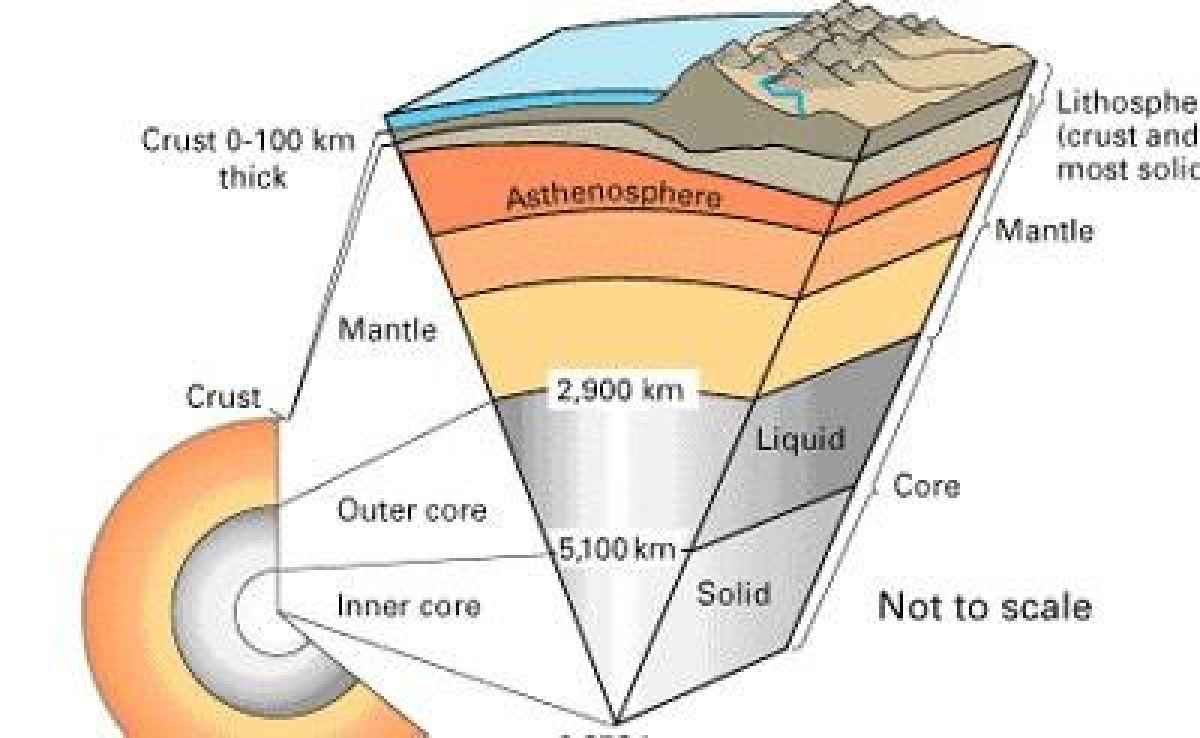
To briefly tell this story, consider that Earth’s crust is broken into great slabs of rock called tectonic plates. These plates float on the layer of Earth known as the mantle. The mantle is mostly solid, although it can move very slowly. This is like biscuits floating on thick honey.
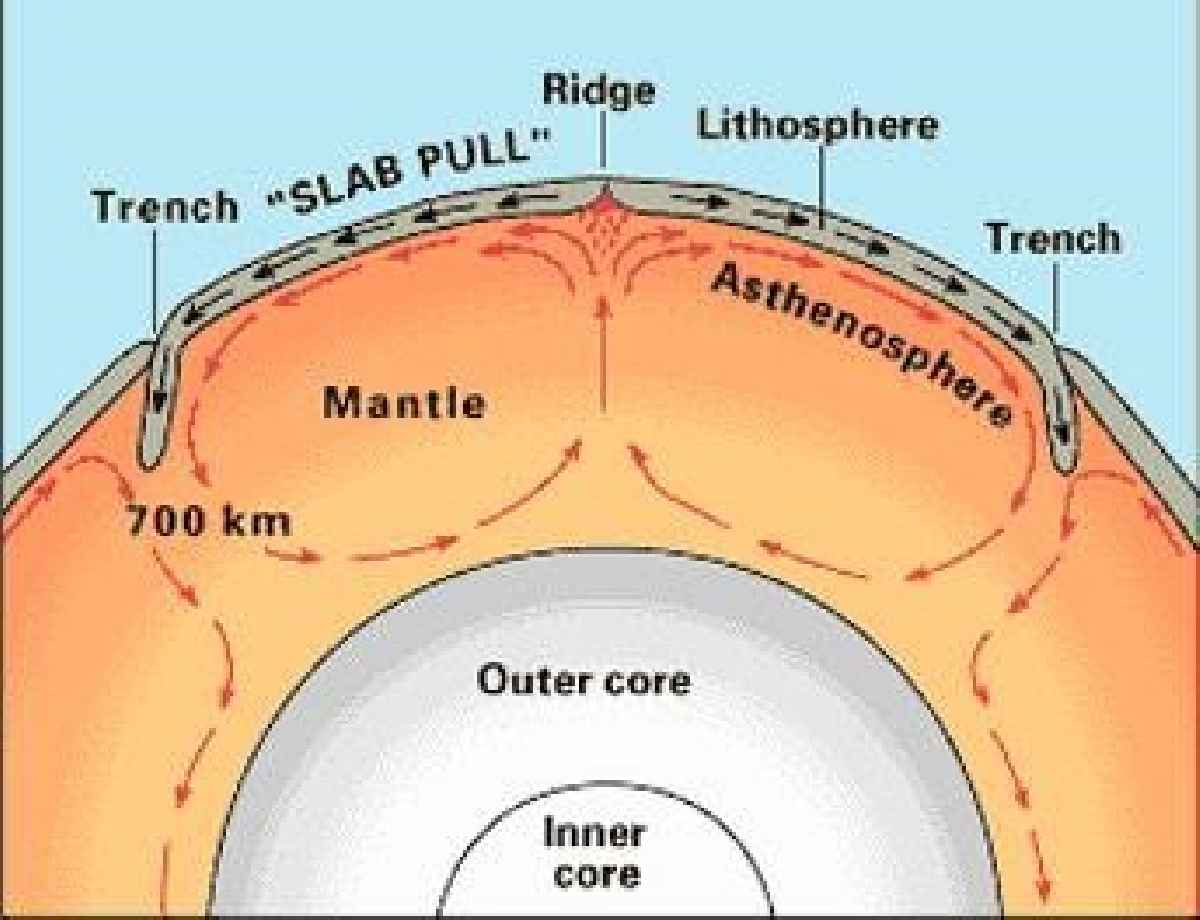
Heat from the outer core is transferred to the lower regions of the mantle. As the mantle heats, it becomes less dense. This less dense material begins to rise (just like hot air). The cooler mantle under the crust is denser; it sinks. As it sinks, it warms, setting up a cycle called a convection current. Geologists are pretty confident that it is these convection currents in the mantle that cause tectonic plates on top to move around the surface. Just remember, this stuff is like really (really) thick honey, it is slow-moving, but strong.
When one tectonic plate (moving at about the speed your fingernails grow) collides with another plate, then one side subducts (sinks) under the other, pushing up mountain ranges on the upper plate. Sudden movements (or slippages) in these plates is what causes earthquakes. Plate tectonics is the process that is generally responsible for really large mountain ranges along the edges of the plates.
Cool stuff also happens within these plates as well. As areas of these plates stretch, then earthquakes and faulting (cracking of the rock) cause some areas to sink, leaving behind some higher areas. In Tassie, the areas that sunk were covered by seawater, and the highlands that remained formed a chain of islands.
After the stretching comes the squeezing. As the plates are squeezed, the pressure leads to the formation of volcanoes (over millions of years). Volcanoes spew out lava, forming new rocks and transforming older rocks.
Dolerite
Dolerite is not super common around the world, but it is one of the defining features of Tasmania’s landscape. Dolerite (aka diabase in North America) is an igneous rock that is formed deep in the earth. The hot liquid rock is then squeezed between other rocks closer to the Earth’s surface. As this rock cools it cracks, often forming tall columns or big blocks. These cracks get bigger over time with freezing and other erosion. This means the mountains are still changing today, in a slow process. It is this dolerite and its columns that dominate the mountains of Tasmania.
The creation of the rock is only half of the story. The spectacular peaks don’t so much grow out of the ground, but rather the land around them is removed to reveal their glory.
Tearing down to create mountains
Geological time is not something that happened in the past, it is still happening today and will continue as long as the Earth exists. Plates are still moving, pushing areas up or down, creating new rocks and even swallowing up old ones.
As this happens, weathering and erosion are constantly working to tear down what has been built. Weather and water, in the form of wind, rain, frost, streams, rivers and glaciers, are working to return mountains to dust.
In brief, weathering crumbles rocks and minerals into smaller pieces. Erosion carries these pieces away by water, wind, glaciers, and gravity, often transporting pieces for long distances.
The important thing to remember with any form of erosion is that the softer material erodes faster than the harder. Harder rocks like dolerite stay in place for much longer than softer sandstone. This means that mountains like Cradle Mountain and Barn Bluff did not so much grow in place, but have been revealed (and continue to be revealed) over time, as the softer (outer) rock around erodes away. Hard rocks do still erode, so dolerite columns do still collapse, and large boulders tumble down.
Sculpted by ice
On colder days it is not so hard to imagine that parts of Tasmania where not only covered in ice but by large glaciers.
Glaciers have shaped much of the landscape that we picture as iconic Tasmania. Glaciers form when snow and ice accumulate, year after year, until a large mass of ice becomes so thick, it is compressed under its own weight. Gravity causes this ice to flow through stream valleys. Glaciers are not a static block of ice, but a river of ice. The glaciers in Tasmania are long gone. They were much more common around the world during the many ice ages of the past.
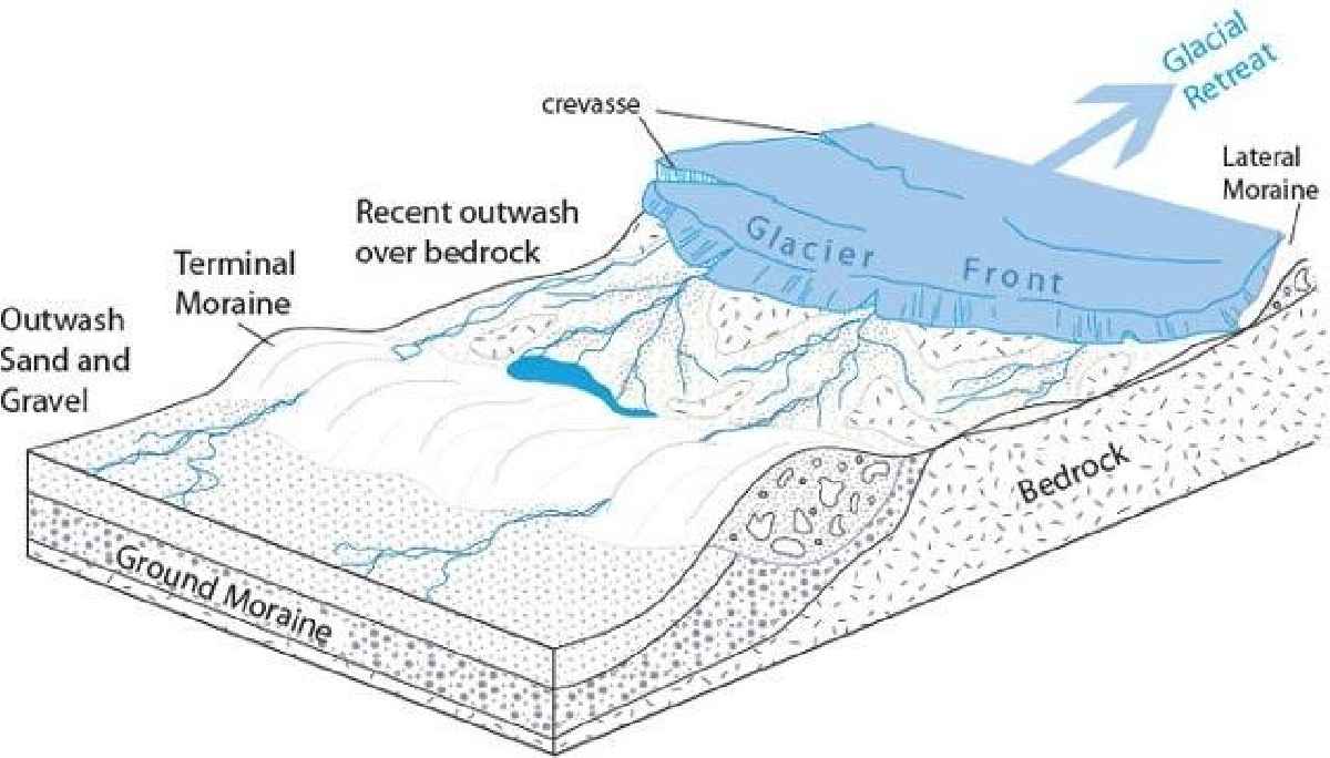
Glaciers are often fed by more snow and ice precipitating and accumulating at higher elevations. If ice builds up at its source, a glacier may flow at rates ranging from a metre a year to a metre a day. As a glacier flows downhill, it grinds away whatever it is sitting on - with tremendous force. It picks up rocks from its bed and sides them, grinding some to a fine powder (called silt) and plucking up larger chunks of rocks.
‘Erratics’ are rocks foreign to the surrounding terrain, that have been transported in and dumped by a glacier. They differ from the types of rock found where they are deposited.
Not all is sculpted by Ice
As glaciers grow, they do not cover the whole earth, but leave areas exposed. We know that glaciers grind areas smooth, but areas they do not touch (like peaks of mountains) are left in all their rugged glory. These areas untouched by glaciers are called ‘nunataks’ by geologists. As you walk through Tassie and look up at jagged peaks from rolling valleys you can pretty safely assume you are standing where there was once a glacier and looking towards a nunatak. The peaks of Cradle Mountain are a perfect example of nunataks.
It is not just the mountains
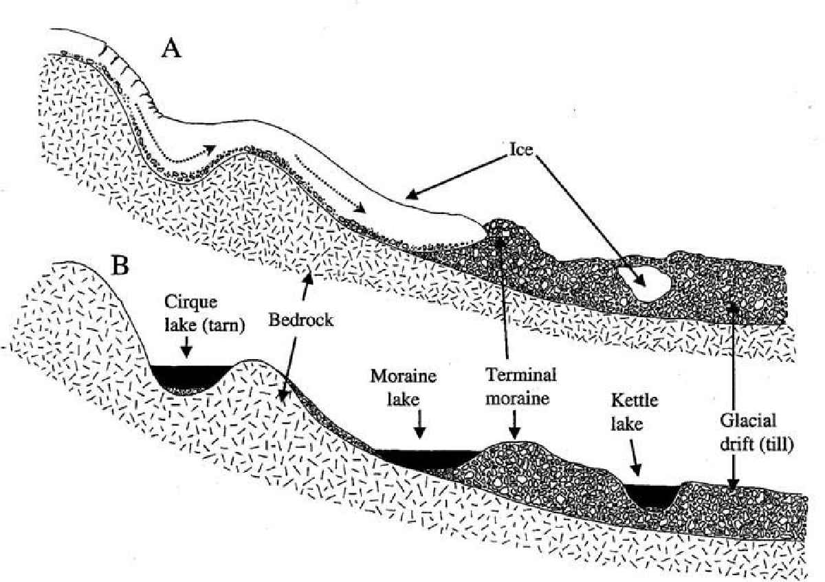
The rocks embedded in glacial ice grind away at bedrock, forming the jagged ridges and deep U-shaped valleys found in the range. Large blocks of ice can be stranded in the moraines (piles of dirt and rocks), left behind by retreating glaciers. When glaciers finally melt, they leave behind depressions that form different types of lakes, such as Cirque lakes (or tarn), Moraine lakes, or Kettle lakes.
Read more about the geology and time frames of the area.